Pintler Creek Trail

Trail length: 7.1 miles
Difficulty: Moderate
Trail Begins: End of Pintler Creek Road 185
Trail Ends: The junction with the Continental Divide Trail 9
At the end of Road 185 is a large graveled parking area with a stock unloading ramp, hitch rails, feed bunk, and toilet at the trailhead. The Anaconda-Pintler Wilderness Boundary is just north of the trailhead. A visitor wilderness registration box and sign is near the boundary. Good stock forage can be found at Pintler Meadows 1 mile up the trail. Another marginal stock camp is located at the junction with Continental Divide Trail 9, forage is limited elsewhere. Oreamnos Lake contains a few fish. Loop hikes are possible using the Mudd Ridge Trail 742 and the Beaver Creek Trail 368.
Pintler Creek Trail (37) is in great condition with a few wet areas and has a gentle steady climbing grade. The trail is cleared and well maintained each year. No motorized vehicles or mountain bikes are allowed in the wilderness area. Snow may persit until late June, especially in the high country such as Pintler Pass. The use is moderate.
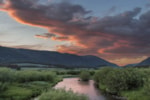
Pintler Creek Trail 37 starts out in lush lodgepole pine forest passing a few small potholes where one can often see moose. One mile in the trail approaches Pintler Meadows, a beautiful marshy flood plain for Pintler Creek and follows the meadow for the next mile. The trail stays in the timber on the east side of the meadow. Two thirds up the meadow the Beaver Creek Trail 368 takes off to the west across the meadows towards Beaver Creek. This trail is steep for most of its' length and finally joins with the Continental Divide Trail 9 near Elk Park. The Pintler Creek Trail 37 continues up Pintler Creek climbing at an easy grade towards Oreamnos Lake and the junction with the Continental Divide Trail 9. Scenery is lush lodgepole pine forest and spruce and subalpine fir in the wetter areas. Many wildflowers such as lupine and buttercups can be found. Nice campsites exist along the trail in the various small meadows and at the junction of Pintler Creek Trail 37 with Continental Divide Trail 9.
USGS Map: Pintler Lake, Warren Peak, Anaconda-Pintler Wilderness